Meander through the deep woods of the Wissahickon Valley and you can't help but happen upon traces of a different time.
This item is available in full to subscribers.
We have recently launched a new and improved website. To continue reading, you will need to either log into your subscriber account, or purchase a new subscription.
If you are a digital subscriber with an active subscription, then you already have an account here. Just reset your password if you've not yet logged in to your account on this new site.
If you are a current print subscriber, you can set up a free website account by clicking here.
Otherwise, click here to view your options for subscribing.
Please log in to continue |


Meander through the deep woods of the Wissahickon Valley and you can't help but happen upon traces of a different time – a randomly placed wall, perhaps, or the remains of an old stone building.
We usually pass them by without much notice. We're there for the park experience, after all, so it's easy to forget that our verdant valley was once teeming with commercial activity and full of its related buildings.
While the vast majority of those structures were swept away after the valley was incorporated into Fairmount Park, remnants of their long history in the connected valleys of the Wissahickon, Cresheim, and Monoshone creeks tell a story all their own.
The first builders
The local indigenous Lenni Lenape people were the first to build in this region. Surviving archaeological evidence suggests they lived in villages on flatter lands near water, so more likely settled along the Schuylkill River and the upper reaches of the Wissahickon Creek in the Whitemarsh Valley than on the steep slopes of this valley gorge.
Their buildings were typically single-doorway wooden wigwams that varied in size. As far as we know, they used degradable organic materials and not stone, and thus none have survived. We do have a few early images of these structures, both in this area and up toward New York City, but it is unclear how reliable those images might be.
European settlers
Next came the earliest Dutch and Swedish immigrants, who arrived to settle mostly along the Delaware River during the 17th century. In 1683, William Penn sold 2,675 acres of "the German Township" to Daniel Pastorius and other investors in the Frankfurt Land Company – kickstarting European development of what is now Northwest Philadelphia.
Their earliest buildings were made of wood and have also since disappeared. One of the first mills in what is now Rittenhouse Town on the Monoshone Creek, a tributary of the Wissahickon, is believed to have been constructed by Daniel Rittenhouse as early as 1687. But only stone structures have survived the intervening centuries, and the oldest remaining one was built in 1707.
One of the most colorful of early local wooden buildings was constructed around that time on the hill above Rittenhouse Town: a multi-purpose religious structure later dubbed the Monk’s Priory. The German Pietist religious leader and mystic Johannes Kelpius, drawn to the region by William Penn’s policy of religious freedom, established a small community of followers who believed the End of Days would occur in 1694. They erected a log building that contained a shared worship area, monks' cells, and an astronomical observatory in the second-story belfry.
When the date of their doomsday event came and went, the community gradually disbanded, and Kelpius died in 1708.
Their long-gone structure is believed to have been located near the section of Hermit Lane that abuts Wissahickon Avenue, and was not the stone-lined hole in the park hillside that some mistakenly know as "Kelpius' Cave." With apologies to Kelpius enthusiasts, that was likely a later root cellar.
The industrial era
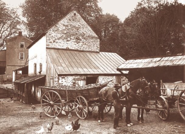
This region was strategically positioned between the fertile farmlands and mines to the west and north, the growing village along lower Germantown Avenue, and the larger population center of Philadelphia to the east. The movement of water in the creek provided power – and a burgeoning commercial mill industry soon followed.
During the 18th and early 19th centuries, the area we now call Wissahickon Park became home to all sorts of buildings – many of which were constructed right on the edge of the water. Some 60 or 70 mills were active along the Wissahickon, Cresheim, and Monoshone creeks during those years. Sometimes they were powered by dams that created mill ponds, some of which survive, while others used mill chases that channeled water to turn interior or exterior mill wheels.
These mills did a wide variety of work: gristmills turned various grains into flours for cooking; lumber mills cut logs into beams and boards for construction; flax mills extracted the oil from flax seeds and turned the remaining fibrous plant material into paper; and fulling mills extracted oil and grease from raw wool.
They also needed the barns, stables, warehouses, and houses that were built to support their activity, and roads for the wagons that hauled materials in and out of the valley. A number of those roads remain in use today.
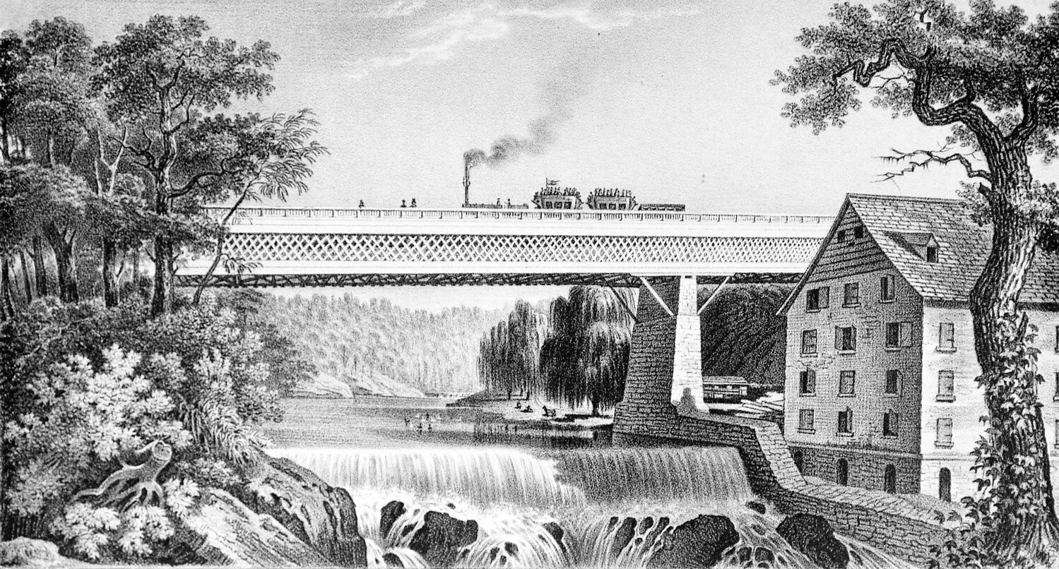
Then came steam
The advent of steam power in the second quarter of the 19th century significantly altered the local economy. Mills that no longer required moving water started to relocate to flatter areas that could accommodate the larger buildings and workforces they needed for their expanding businesses.
Thus began, for example, the mills of nearby Manayunk, which offered the bonus of shipping transport along the recently constructed Schuylkill River Canal.
At the same time, the Romantic movement in art and literature had arrived from Europe and encouraged a new aesthetic appreciation of nature. The rugged beauty of our Wissahickon gorge attracted national attention, including in the writings of Edgar Allen Poe and Walt Whitman, and in paintings and photography.
By 1854, when our northwestern suburbs were "consolidated" into the larger municipality of Philadelphia, the city had begun to worry about its water supply. Over the latter half of the 19th century, the city gradually bought up the declining mills along the creeks and demolished almost all of the buildings in what is now Wissahickon Park.
A few remain, however – including the handsome Livesey House, which was built around 1725 at the end of Livesey Lane, near the remaining dam that once powered a large mill. Along Cresheim Creek above Devil’s Pool are scattered ruins of a variety of other mill-related structures, including dams for mill ponds, retaining walls, and former bridges.
The nearest surviving and functioning mill building is Springfield Mills in the Morris Arboretum, which dates from 1761 and is well worth a visit.
Crossings, old and new
All that waterside activity, of course, required a variety of bridges. The earliest were made of wood, which have since rotted or been washed away.
The stone bridge now known as the Hermit Lane Bridge, visible from Lincoln Drive at the lower end of the creek almost underneath the much later Henry Avenue Bridge, was one of these early crossings. It replaced earlier wooden bridges in about 1790, and provided an important link between Roxborough and East Falls, and eventually into Philadelphia.
The current Blue Stone Bridge, farther up the creek on the Forbidden Drive, is another stone replacement for an important early crossing. It linked Shurs Lane in Roxborough to the Germantown side of the creek. Travelers could then continue along the east side of the creek into Rittenhouse Town, where they could access another bridge across the smaller Monoshone Creek and continue up Rittenhouse Street into central Germantown.
It is hard to imagine today, but for many years that bridge was the only connection between what was then a busy Germantown and the farms in Roxborough. It was also used by travelers who sought a western road bypass around Philadelphia.
Over the years, additional bridges were constructed at key junctures along the creeks, including those at Bells Mill Road, Rex Avenue, Valley Green Road, and a few others. A perennial favorite is the single remaining covered bridge at Thomas Mill.
The much higher and wider spans of the Henry Street and Walnut Lane bridges came with the advent of the automobile in the early 20th century. Thankfully, other later large highway bridges across the Wissahickon and Schuylkill valleys – which would have significantly impacted land use across the Northwest – were planned, but never built.
Roads and recreation
Some might assume that our beloved Forbidden Drive is perhaps an upgraded continuation of some historical road that has long followed the creek. But it is actually quite recent. Early maps show no roads along the steep sides of the Wissahickon Creek.
Too shallow and rocky for navigation by boat, the creek lies at the bottom of a gorge, with walls too steep for those water-side roads. The people of Germantown, East Falls, or Roxborough had to use roads that descended directly down the hillside to access the mills hundreds of feet below.
It was a challenge all its own – on busy days, hundreds of wagons would descend those steep slopes, only to turn around and haul their loads back up to the stores on Germantown Avenue where those goods would be sold.
A better system was clearly needed. In 1834, the private Wissahickon Turnpike Company was formed to push for the construction of what is now the lower section of Lincoln Drive, and blasted through the spine of rock that runs from East Falls across to Roxborough. That road eventually reached Rittenhouse Town.
The construction of what is now Forbidden Drive happened piecemeal over the following decades, driven by the expanded recreational use of the Wissahickon Valley. After the turn of the 20th century, as heavier traffic brought more demand for faster roads, there were heated debates over who could use it. The battle ended in 1924 when the city designated the entire length of the road from its juncture with Lincoln Drive up to Northwestern Avenue as "forbidden" to cars.
By that time, cars could already continue along the extension of Lincoln Drive beyond Rittenhouse Town, which had been constructed along the valley of the Monoshone Creek. Lincoln Drive now runs on top of that creek, which still passes through massive underground pipes as part of the City water system.
Roadhouses and restaurants
The farmers and workers who toiled in those mills created demand for inns and taverns, and they soon followed. Various such inns sprang up along Germantown Avenue and Ridge Pike, close to shops, warehouses, and customers.
But it was not until the mid-19th century and the gradual opening of the valley to recreational use that "roadhouse" restaurants started cropping up closer to the creek, often featuring the local specialty: catfish and waffles.
With the 1821 construction of the Water Works dam, which raised the level of the Schuylkill River and made it easier to navigate, city residents could take boats up to explore the lower reaches of the Wissahickon Creek. Later, as Forbidden Drive was constructed up the creek, visitors could move overland farther up the valley.
It proved to be an insurmountable challenge for the long-term survival of those roadhouses, however, that the Fairmount Park Commission did not allow alcohol. Without that particular attraction, most eventually closed. Only two out of what were probably seven have survived.
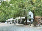
The first is the two-story structure with porches on the lower section of Lincoln Drive at the bottom of Shurs Lane. It was last used by the park police. The second, of course, is the Valley Green Inn – the only roadhouse that is still functioning as a restaurant today. It was constructed in 1850 but later remodeled to look older during the Colonial Revival movement of the late 19th and early 20th centuries. Go have dinner there and raise a glass to the roadhouses of old.
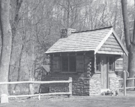
Works Progress Administration
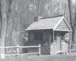
The park’s final phase of building construction was brought to us during the Great Depression, courtesy of the Works Progress Administration (WPA), which was founded in 1935 under President Franklin Delano Roosevelt to grapple with devastating unemployment and provide paid jobs.
The WPA employed some 8.5 million people between 1935 and World War II, and added 40,000 new and 85,000 improved buildings across the country.
Thirteen of those structures are located in the Wissahickon: rustic stone cabins scattered along Forbidden Drive. You’ll find them near bridge crossings, including at Rex Avenue and Kitchen’s Lane, and at the spot where Forbidden Drive ends at Lincoln Drive.
Many thanks to the Friends of the Wissahickon and the Chestnut Hill Conservancy for their extensive records of our area. And to Chestnut Hill’s Historian Laureate, David Contasta, for sharing images from his book Metropolitan Paradise: The Struggle for Nature in the City, Philadelphia's Wissahickon Valley, 1620-2020 (co-authored with Carol Franklin).


