Neighbors who 10 years ago successfully battled development plans for Hillcrest Avenue now find themselves back in the fight.
This item is available in full to subscribers.
You can also purchase this individual item for $1.50
We have recently launched a new and improved website. To continue reading, you will need to either log into your subscriber account, or purchase a new subscription.
If you are a digital subscriber with an active subscription, then you already have an account here. Just reset your password if you've not yet logged in to your account on this new site.
If you are a current print subscriber, you can set up a free website account by clicking here.
Otherwise, click here to view your options for subscribing.
Please log in to continue |
A group of neighbors who 10 years ago successfully battled development plans for Hillcrest Avenue now find themselves back in the fight – and this time they may have to fight City Hall.
The issue stems from environmental concerns over how close 116 and 118 E. Hillcrest Avenue are to a Wissahickon tributary, which runs through the Morris Arboretum property across the street and feeds into the larger Wissahickon Creek. That tributary, the neighbors argue, is close enough to the lots in question that it triggers a city zoning clause that forbids construction within 200 feet of the waterway and its tributaries.
“What (the Wissahickon Watershed Overlay District) does is keep the nonpoint source pollutants – runoff from our roads and lawns – from going right into the streams,” said Ruffian Tittmann, the executive director of Friends of the Wissahickon. “There's a whole host of reasons why these controls are in place, but number one is protecting the drinking water supply of Philadelphia.”
It’s a set of facts that, more than a decade ago, helped neighbors win their organized opposition to a developer who wanted to build single-family homes on the property.
But now the matter has returned. This time, the city says it can’t refuse building permits because the Philadelphia City Planning Commission hasn’t updated its old maps – which don’t show the tributary in question.
According to Bruce Bohri, a spokesperson for the city Zoning Board of Adjustment (ZBA), neither their agency nor the city Department of Licenses and Inspections (L&I) have the power to update the Philadelphia City Planning Commission’s 1973 map, which the L&I must use. Any changes to that map would require a legislative process.
In other words, they say, their hands are tied.
“The zoning permit for 118 Hillcrest was issued by L&I ‘by-right,’ after review by the Planning Commission,” Bohri said. “The Planning Commission uses a physical map for its determinations in reviewing permit applications in the Wissahickon Watershed Overlay. The map is based on a study that was conducted in 1973; however, it still provides the legal basis to meet the requirements of this code section. Any change to that map or its usage would require a legislative process.”
A shaggy dog story of bureaucracy
The story first began back in 2013, when Christopher Blatney sold the land to Amit Azoulay, who intended to develop single-family homes on the property.
What initially began as a discussion about matching the style of the construction to the surrounding homes turned into a dispute over protecting the environment. One of the neighbors, lawyer Stacy Mogul, hired a survey company to identify the tributary and show the 200-foot buffer zone deep inside the lots in question.
Mogul, along with a group of neighbors, took that survey and appealed to the ZBA, leading to a long legal battle that stretched into 2018. Ultimately, the ZBA sided with the neighbors on one of the two properties but said neighbors had missed a deadline to file an appeal on the other.
So the city used the old map to decide the permit status for one property, and the newer survey for the other. This, of course, meant that one lot was deemed ‘buildable’ and the other was not.
At the time, it didn’t matter, because nothing was built. As the legal battle concluded, Mogul approached Azoulay and suggested that he sue Blatney since Mogul believed that Blatney may not have disclosed the property's proximity to the tributary. While Azoulay’s subsequent actions are unclear, in 2019, Blatney re-purchased the property from Azoulay.
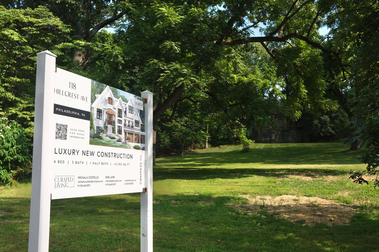
Then three years later, in 2022, L&I granted Blatney a zoning permit for a single-family home at 118 E. Hillcrest. The proposed property would be a single-family home with a three-car garage just behind the Watershed setback identified by the 1973 map.
Mogul, who is a lawyer, had by this time moved out of the neighborhood. But a new group of neighbors, led by Laura Dingfield, tried to fight the development– and organized an appeal to the ZBA.
Again, the ZBA said their appeal had missed a deadline.
“I feel like the zoning board completely failed to deliver on its mission,” said Yaron Simler, another neighbor. “Did anybody in the zoning board bother to look at the map and say, ‘Oh, right,’ I don't think so.”
Now it seems the problem has returned. Dingfield first noticed it last year, when she saw for-sale signs on both properties. Alarmed, she and a group of near neighbors looked into it – and realized that 118 E. Hillcrest was again listed on the MLS as a buildable property – for $545,900.
Eleven years later, L&I used the same outdated map to determine buildable status for 118 Hillcrest – and once again neighbors are not having it. They’ve organized a petition that has so far gathered 138 signatures.
“In order to protect the Wissahickon, the community would very much like to see a legislative resolution to this bizarre ordinance based upon an outdated and inaccurate map,” Dingfield said.
“We're not opposed to development (in general), I have three little kids who would love to have neighbors,” she continued. “We also love living in this area because of the natural beauty of the Wissahickon, and so I think we're more concerned about how to keep it that way.”
While the Chestnut Hill Conservancy was not previously informed about the petition, a spokesperson said in a statement that the “critical importance of this site within the Wissahickon watershed, directly across from the Morris Arboretum and impacting the Swan Pond, is recognized.”


